


Graptemys ouachitensis, 103
Graptemys ouachitensis Cagle 1953 –
Ouachita Map Turtle
Richard C. Vogt1
1Coordinaçao de Biodiversidade, Instituto Nacional de Pesquisas da Amazônia,
2936 Av. André Araújo, Petrópolis, CEP 69.067-375, Manaus, Amazonas, Brazil
[[email protected]; [email protected]]
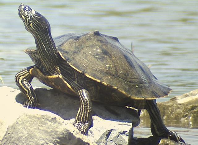
Summary. – The Ouachita Map Turtle, Graptemys ouachitensis (Family Emydidae), is a medium-sized river turtle (carapace length to 160 mm in males, 260 mm in females) common in large rivers and oxbow lakes in areas of moderate to rapid current, primarily within the Mississippi River drainage of the central United States. Ouachita Map Turtles prefer large clear water rivers, males are more likely to be found in areas with strong current, while females can often be found feeding in backwater areas; they are known to hibernate behind wing dams in the Mississippi River. Some individuals may have a wide complete postorbital crescent separating the orbit from the lateral neck stripes; this crescent may be broken with or without one to four stripes entering into contact with the orbit. The under surface of the head is characterized by four prominent bright yellow spots, one on each mandible, one at the jaw symphysis, and another in the gular region. There is a low keel on the carapace. The species is omnivorous, feeding on a wide variety of aquatic plants, as well as aquatic insects. The Ouachita Map Turtle, like all species of Graptemys, is listed in CITES Appendix III, which offers no protection, but requires documentation of how many are exported internationally. Population and ecological studies have found this species to be abundant in many localities throughout its range; no specific conservation or management practices need be adopted for the widespread subspecies G. o. ouachitensis at this time, though population monitoring of the restricted subspecies G. o. sabinensis is recommended.
Distribution. – USA. Graptemys ouachitensis occurs from the Mississippi River in Wisconsin and Minnesota east into Indiana, Ohio, and West Virginia, and south in the Mississippi River Basin through Louisiana, west to Oklahoma and Kansas, and south to eastern Texas.
Synonymy. – Graptemys pseudogeographica ouachitensis Cagle 1953, Malaclemys pseudogeographica ouachitensis, Graptemys ouachitensis, Graptemys ouachitensis ouachitensis.
Subspecies. – Two are recognized in this account: 1) Graptemys ouachitensis ouachitensis Cagle 1953 (Ouachita Map Turtle) (distribution: from Wisconsin and Minnesota east into Indiana, Ohio, and West Virginia, and south through eastern Louisiana and west to Oklahoma and Kansas); and 2) Graptemys ouachitensis sabinensis Cagle 1953 (Sabine Map Turtle) (distribution: Sabine-Neches, Calcasieu, and Mermantau river drainages of southwestern Louisiana and eastern Texas) (synonymy: Malacoclemmys intermedia Baur in Beyer 1900 (nomen nudum), Graptemys intermedia, Graptemys pseudogeographica sabinensis Cagle 1953, Malaclemys pseudogeographica sabinensis, Graptemys ouachitensis sabinensis, Graptemys sabinensis).
Status. – IUCN 2018 Red List: Least Concern (LC, assessed 2011); CITES: Appendix III (USA) as Graptemys spp.; US ESA: Special Concern.
Citation:
Vogt, R.C. 2018. Graptemys ouachitensis Cagle 1953 – Ouachita Map Turtle. In: Rhodin, A.G.J., Iverson, J.B., van Dijk, P.P., Buhlmann, K.A., Pritchard, P.C.H., and Mittermeier, R.A. (Eds.). Conservation Biology of Freshwater Turtles and Tortoises: A Compilation Project of the IUCN/SSC Tortoise and Freshwater Turtle Specialist Group. Chelonian Research Monographs 5(11):103.1–13. doi: 10.3854/crm.5.103.ouachitensis.v1.2018; iucn-tftsg.org/cbftt/.
(Adobe Acrobat 6.0 or later required)
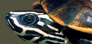
Graptemys ouachitensis ouachitensis, Paris Landing State Park, Henry Co., Tennessee, USA.
Photo by P.V. Lindeman.
Distribution:
.jpg)
Historic distribution of Graptemys ouachitensis in central and southern USA. Yellow dots = museum and literature occurrence records of native populations based on Iverson (1992) and Lindeman (2013; In Press; unpubl. data); orange dot = erroneous earlier literature record (Minton 2001); red shading = projected historic distribution of G. ouachitensis ouachitensis; blue shading = G. ouachitensis sabinensis. Distribution based on GIS-defined level 12 HUCs (hydrologic unit compartments) constructed around verified localities and then adding HUCs that connect known point localities in the same watershed or physiographic region, and similar habitats and elevations as verified HUCs (Buhlmann et al. 2009; TTWG 2017), and adjusted based on subsequent data.